PostHeaderIcon Antarctic’s Pine Island glacier produces giant iceberg

Pine Island Glacier (PIG), the longest and fastest flowing glacier in the Antarctic, has spawned a huge iceberg.

The block measures about 720 sq km in area – roughly eight times the size of Manhattan Island in New York.

Scientists have been waiting for the PIG to calve since October 2011 when they first noticed a spectacular crack spreading across its surface.

Confirmation that the fissure had extended the full width of the glacier was obtained on Monday.

It was seen by the German TerraSAR-X satellite.

This carries a radar instrument that can detect the surface of the ice stream even though the Antarctic is currently in the grip of winter darkness. Check for guides and tips.

The berg that broke away was part of the PIG’s ice shelf – the front segment of the glacier that lifts up and floats as it pushes out into the ocean. The shelf will reach tens of km beyond the grounding line.

German researchers have been receiving images from TerraSAR-X every three days or so, hoping to understand better the processes that drive the glacier forward and prompt it to fracture.

This will help them improve the computer models that are used to forecast future changes in the Antarctic.

TerraSAR-XTerraSAR-X can see the Earth’s surface even when it is in darkness and covered by cloud

“We were very keen to see how the crack propagated,” said Prof Angelika Humbert, a glaciologist with the Alfred Wegener Institute.

“We need proper calving laws, to be able to describe the evolution of ice sheets over centuries,” she told BBC News.

Very big tabular bergs will come off the end of the ice shelf every 6-10 years. Previous notable events occurred in 2007 and 2001.

It is a very natural process and scientists say it should not be tied directly to the very real climate changes that are also affecting this part of the West Antarctic Ice Sheet.

Satellite and airborne measurements have recorded a marked thinning and a surge in velocity of the PIG in recent decades.

Map of Antarctica showing Pine Island Glacier

This has been attributed in part to warmer waters getting under, and melting, the ice shelf. The PIG’s grounding line has pulled back further and further towards the land.

The glacier’s behaviour means it is now under close scrutiny, not least because it drains something like 10% of all the ice flowing off the west of the continent.

“The PIG is the most rapidly shrinking glacier on the planet,” explained Prof David Vaughan from the British Antarctic Survey (BAS).

“It’s losing more ice than any other glacier on the planet, and it’s contributing to sea level rise faster than any other glacier on the planet. That makes it worthy of study.”

BAS has recently deployed a series of instrumented “javelins”along the PIG to monitor its movement.

Rift in PIG
A Nasa plane was the first to detect the expanding crack in October 2011

When the big crack propagating across the 30km width of the PIG was first photographed in 2011 by a Nasa airborne expedition, many assumed the moment of final calving would come quite quickly.

That it took almost two years for the tabular berg to break away is something of a surprise, concedes Prof Humbert.

What should not be a surprise, she says, is that it has occurred in deep winter when the ocean is covered in sea-ice. This relatively thin covering would always be overwhelmed by the internal stresses in the massive ice shelf.

What will be interesting now, she adds, is to see how long it takes for the berg to move out of the bay in front of it. It could take several months. TerraSAR-X will provide the tell-tale data.

The world’s largest recorded iceberg was the tabular block that became known as B-15.

When it broke off the Ross Ice Shelf in 2001, it had a surface area of about 11,000 sq km. It took years to melt away as it moved out into the Southern Ocean.

- credit, BBC

Home cleaning services in Chicago


PostHeaderIcon Stunning New Solar Atmosphere Images Could Help Solve Longstanding Mysteries

An image of an active, magnetically complicated region of the Sun captured by the new Hi-C instrument. It shows plasma in the outer solar atmosphere at a temperature of 1-2 million degrees Celsius. The inset box at bottom left shows ‘sparkle’ features that are releasing vast amounts of energy into the corona. The box at top right shows a close-up of part of a solar filament where ‘blobs’ of solar plasma flow along thread-like ‘highway’ structures. Credit: NASA MSFC and UCLan.

[ Watch the Video: Stunning New Solar Atmosphere Images Could Help Solve Longstanding Mysteries ]

Thanks to an innovative new camera on board a sounding rocket, an international team of scientists has managed to capture pictures of the sun’s outer atmosphere that are five times sharper than any previous images.

The images, which were scheduled to be presented by University of Central Lancashire professor Robert Walshat the Royal Astronomical Society (RAS) National Astronomy Meeting on Monday, were captured using the NASA High Resolution Coronal Imager (Hi-C).

Walsh and colleagues from the UK, US and Russia used a sounding rocket to launch Hi-C from the White Sands Missile Range in New Mexico, RAS officials said. During its brief flight, the Hi-C team was able to secure the high-quality solar corona images, acquiring roughly one picture each five seconds. They were also reportedly able to discover “fast-track ‘highways’ and intriguing ‘sparkles’ that may help answer a long-standing solar mystery.

According to the researchers, those dynamic bright spots switch on and off. They last approximately 25 seconds, are roughly 680 kilometers (423 miles) across and release at least 10,000 times the annual energy consumption of the entire UK population during each event.

As such, these sparkles clearly demonstrate that massive amounts of energy are being added into the corona, and could then be released violently in order to heat the plasma. By discovering them in the Hi-C images, the authors believe they could help explain why the sun’s corona is about 400 times hotter than the solar surface.

Also in the new images, the researchers report the discovery of “small clumps of electrified gas (plasma) at a temperature of about one million degrees Celsius.” These clumps, they note, “are seen racing along highways shaped by the Sun’s magnetic field,” traveling at approximately 80 kilometers per second (50 miles per second) — or the equivalent of 235 times the speed of sound on Earth.

Each highway is 450 kilometers (280 miles) across, or just about the entire length of the country of Ireland from its northern-most point to its southern-most one, the Society said. These flows are inside a region of dense plasma known as a solar filament. These areas can erupt outward from the sun in phenomenon known ascoronal mass ejections (CMEs), and carry billions of tons of plasma into space.

“If a CME travels in the right direction it can interact with the Earth, disturbing the terrestrial magnetic field in a ‘space weather’ event that can have a range of destructive consequences from damaging satellite electronics to overloading power grids on the ground,” the researchers said. By discovering and learning more about the nature of these so-called solar highways, scientists might be able “to better understand the driving force for these eruptions and help predict with greater accuracy when CMEs might take place.”

“I’m incredibly proud of the work of my colleagues in developing Hi-C,” Walsh said. “The camera is effectively a microscope that lets us view small scale events on the Sun in unprecedented detail. For the first time we can unpick the detailed nature of the solar corona, helping us to predict when outbursts from this region might head towards the Earth.”


Source: redOrbit Staff & Wire Reports – Your Universe Online


PostHeaderIcon Met Office ‘To Hold Emergency Meeting Over Increasingly Unusual UK Weather’

The Met Office is to hold an emergency meeting of experts to discuss the increasingly unusual weather in the UK, it has been reported.

It follows the coldest spring in more than 50 years, as well as droughts and floods in 2012 and the freezing winter of 2010.

Climate scientists and meteorologists will travel to the forecaster’s headquarters in Exeter on Tuesday for the unprecedented meeting, the Guardian said.

Attendees are expected to debate whether the changing weather pattern in the UK, and in northern Europe, is because of climate change or simply variable weather.

A Met Office spokesman told the Guardian: “We have seen a run of unusual seasons in the UK and northern Europe, such as the cold winter of 2010, last year’s wet weather and the cold spring this year.

Met Office

“This may be nothing more than a run of natural variability, but there may be other factors impacting our weather … there is emerging research which suggests there is a link between declining Arctic sea ice and European climate – but exactly how this process might work and how important it may be among a host of other factors remains unclear.”

Experts will identify what further research is needed and discuss whether climate models need to be revised to take into account any recent changes to weather patterns

It comes after the National Farmers Union reported that wheat harvests are likely to be around 30% lower than last year as a result of the extreme weather.

Earlier this month the Met Office said below average temperatures throughout March, April and May made it the fifth coldest spring in national records dating back to 1910 and the coldest spring since 1962.

March was “exceptionally” cold, averaging 2.2 °C.

credit


PostHeaderIcon BREAKING: London Bridge train station closed amid Twitter reports of man carrying an axe

Image via CrunchBase

LONDON Bridge station has been shut and a strong police presence have gathered amid reports on Twitter of a man being spotted with an axe.

First Capital Connect confirmed that the station has been closed, while British Transport Police said there is an ‘incident ongoing’.


One user tweeted: “#londonbridge #shutdown after a man was spotted with an axe no one was allowed out of in. Armed police everywhere.”

An armed police officer told our reporter on the ground that they were called to the scene after reports of a man in possession of a weapon believed to be an axe.

Station was evacuated and closed for twenty minutes, however no one has been detained and it was later re-opened.

More to follow…  Station was evacuated and closed for twenty minutes, however no one has been detained and it was later re-opened.

credit


PostHeaderIcon Conspiracy theory connect-the-dots

Had to laugh!

conspiracy


PostHeaderIcon Ring Of Fire Earthquake Hits Russia And US prompting tsunami warning

Tremors are felt from thousands of miles away in Moscow as two quakes strike in the turbulent Ring Of Fire region

A view of Moscow's Kremlin, Ministry of Foreign affairs and Moscow City business district

Two earthquakes have hit the Ring of Fire area, registering magnitudes of 8.2 and 5.7 and prompting a tsunami warning.

Moscow felt tremors from the more powerful quake, causing some people to evacuate buildings despite the epicentre being more than 4,000 miles to the east.

The US Geological Survey said the epicentre of Thursday’s quake was in the Kuril-Kamchatka arc, one of the most seismically active regions in the world.

Marina Kolomiyets, from the Russian Academy of Sciences, said it originated 375 miles under the sea bed in the Sea of Okhotsk, just off Russia’s east coast and north of Japan.

A tsunami warning for the Sakhalin and the Kuril islands was issued, but lifted soon afterwards.

Tremors are extremely rare in Moscow, with the last recorded instance in 1977. Witnesses also reported feeling the tremors across Siberia.

“There were repercussions of the quake in Nizhny Novgorod, Moscow and Europe, in particular Romania,” said Anatoly Tsygankov from Russia’s Rosgidromet environmental monitoring service.

Kamchatka, eastern Russia


Eastern Russia’s Kamchatka peninsula is prone to eathquakes

“Practically the whole continent shook.”

No casualties have been reported.

A second, smaller 5.7 magnitude quake also struck the US.

It hit northern California’s Plumas County at 8.47pm local time and was centred six miles west of Greenville.

Sacramento television station KCRA-TV said the tremors were felt in the city, some 145 miles south of the epicentre.

Eight aftershocks ranging from 2.6 to 3.5 magnitude were also recorded. So far, no injuries or damage have been reported.

The Ring of Fire is a horseshoe-shaped area located around the edge of the Pacific Ocean.

The vast majority of the world’s volcanoes and earthquakes occur in the area because of the movement and collisions of the Earth’s tectonic plates.

credit


PostHeaderIcon Magnitude 7.4 quake strikes in sea off Tonga -USGS

A magnitude 7.4 earthquake struck in the sea 177 (285 km) miles southwest of Tonga’s capital Nuku’alofa, the U.S. Geological Survey reported on Thursday.

It said the quake was recorded at a depth of 106 miles and had struck at 1719 GMT.

The Pacific Tsunami Warning Center on its website said that no “destructive Pacific-wide tsunami” was expected.

English: Tsunami hazard sign


PostHeaderIcon GPS Could Issue Tsunami Alert in Minutes

Still from an animation show how seafloor features influenced the March 11 japan tsunami.
An image from an animation using satellite observations of the March 11 tsunami that shows how the waves of the tsunami were influenced by seafloor features. Wave peaks appear in red-brown, depressions in blue-green and ocean floor topography is outlined in gray.
CREDIT: NASA/Jesse Allen, using data provided by Tony Song (NASA/JPL)


The global positioning system (GPS) — the same system that helps people navigate unfamiliar places — could also serve as an early-warning system for tsunamis, according to new research.

When a magnitude-9.0 earthquake struck Japan on March 11, 2011, coastal residents received an inaccurate estimate of the earthquake’s magnitude before the waves hit and leveled thousands of buildings.

The area under alert was warned based on an estimatedearthquake magnitude of 7.9 — 130 times less intense than the actual quake was — meaning fewer neighborhoods were evacuated in response to the perceived threat.


Researchers behind a new study have said that GPS systems along the coast could have given the residents a better warning. Sifting through the GPS data from stations along the coast and issuing a more accurate tsunami alert based on that data would only have taken three minutes, the study found. [7 Ways the Earth Changes in the Blink of an Eye]

Subduction zones and GPS

Most tsunamis occur when one tectonic plate slides underneath another and causes an earthquake. In the process, the top plate is forced upward, and this uplift of the seafloor pushes on the water above it, setting off the tsunami. How high the ground rose on the seafloor would influence wave heights up on the surface.

The coast also slightly rises or falls along with the ocean floor, making it possible to see these changes through coastal GPS stations. Therefore, areas near these so-called subduction zones can be mapped and measured using GPS to see how much the ground has shifted and in what way it has deformed.

Whereas traditional seismological stations are located some distance away from the source, GPS transmitters can be placed much closer, on the coastline, to where the tsunami occurred, buying valuable time for those looking to escape.

“To really get absolute values of slip, you would need to have stations at the seafloor,” said Andreas Hoechner, a postdoctoral researcher at the GFZ German Research Centre for Geosciences in Potsdam.

“However, [the coastal GPS readings are] good enough to get good tsunami wave estimates.”

A subduction quake makes several ocean waves: crest waves on top of the seafloor that rise, and trough waves on the seafloor that drop down. Additionally, independent research has recently showed that a shoreline’s features also influence the severity of a tsunami’s impact on land.

Reconstructing an alert

To reconstruct what a GPS alert would have looked like during the 2011 temblor, the scientists took information from the Japanese GPS Earth Observation Network (GEONET)the day before, the day of, and the day after the 2011 earthquake. The station is typically used for long-term changes to the ground, such as “relaxation processes” between earthquakes, but has not been applied yet for tsunami warnings, Hoechner said.

While Japan has about 1,200 of these stations, the researchers only used 50 of them in order to take less time to issue an alert. The exact number of stations does not matter in this scenario, Hoechner noted, as long as there are enough to note a rapidly changing height difference between the ground on the coast and the ground further inland.

GPS stations provide more accurate information about ground shifts than seismological stations do, as seismological stations are better suited for looking at the amount of ground shaking — rather than shifting — associated with an earthquake. Both systems are useful in their own ways and should be used together, Hoechner said.

In the case of Japan’s Tōhoku earthquake, a tsunami warning issued just three minutes after the earthquake struck would have provided several minutes for people to scramble to safety. Tsunamis typically hit land about 20 to 30 minutes after they are generated, Hoechner said, depending on the distance between land and the earthquake’s epicenter.

The challenge will be to actually use the GPS sensors for real events, not just for simulating past tsunamis. And the technique could be used not only in Japan, but also in Indonesia. After the devastating 2004 earthquake in that region, there were some GPS stations installed, but the researchers say more are needed to make accurate tsunami warnings.

The results appear in the latest edition of Natural Hazards and Earth System Sciences, an open-access journal of the European Geosciences Union.

Hoechner’s team plans to extend its research to Chile, which was the site of a devastating tsunami in 2010.

credit


PostHeaderIcon Government licensed secret buzzard egg destruction, documents reveal

Government licensed secret buzzard egg destruction, documents reveal

Eggs and nests of protected raptors destroyed to protect pheasant shoot, according to FoI documents

shoot, according to FoI documents

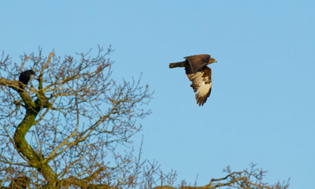
Buzzard in flight in Bedfordshire


Raptors gained legal protection decades ago. This is the first time since that action has been licensed against any bird of prey to protect game shoots. Photograph: Ben Hall/RSPB

A government agency has licensed the secret destruction of the eggs and nests of buzzards to protect a pheasant shoot, according to documents released under the Freedom of Information Act.

The action sets a historic precedent, being the first time such action has been licensed against any bird of prey to protect game shoots since raptors gained legal protection decades ago. Buzzards are recovering from near extinction and now number 40,000 breeding pairs, while 35m pheasants are bred each year for shoots.

It is also less than a year after the wildlife minister, Richard Benyon,abandoned related plans citing “public concerns”. Benyon, whose family estate in Berkshire runs shoots, cancelled plans to spend £375,000 on testing control measures for buzzards around pheasant shoots after a public outcry in May 2012. “I will collaborate with all the organisations that have an interest in this issue and will bring forward new proposals,” he said at the time.

The destruction of the nests, which took place in the last few weeks, was only revealed after the event through a freedom of information request by the RSPB.
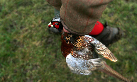
Shooting pheasants : A man holds a dead pheasant which he shot during in Lewknor, southern EnglandA man holds a dead pheasant shot during a pheasant hunt in Lewknor, England. Photograph: Eddie Keogh/Reuters”We were proceeding collaboratively and that is why we are so angry now,” said Martin Harper, the RSPB’s conservation director. “Most people would prefer to see buzzards soaring in the sky. They are big, majestic creatures in the wild and we don’t have many of them in the UK: they are England’s eagle. The fact the licence process takes place without public scrutiny is wrong.”

The licences were issued by the government’s licensing body, Natural England (NE) and permitted destruction of up to four nests and the eggs they held. “The law allows action to be taken against protected species to protect livestock, which includes any animal kept for the provision or improvement of shooting,” said a spokesman for NE. “We rigorously assessed the application [and] were satisfied the case met the criteria.”

The locations of the destroyed nests were not made public. NE stated the issue was “emotive and sensitive” and cited “public safety”. NE issued the licences despite its own expert reviewer stating: “There is no body of published evidence demonstrating that the presence of buzzards is likely to result in serious damage to a game shoot.” A related application to kill sparrowhawks was rejected.

The National Gamekeepers Organisation (NGO) was closely involved in winning the licences and had threatened NE with judicial review if they were not granted. “We believe the long-standing licensing process was correctly used in this case,” said a spokesman. “A few buzzards had been consistently killing a large number of pheasants. Most birds of prey are now at or near record levels in the UK, so conflicts with game management and farming are bound to occur from time to time.”

Pheasants are not native to the UK and were introduced to stock shoots, but the biomass of the population makes it now the single biggest bird species in the countryside. The growing popularity of shoots in the Victorian era saw buzzards poisoned, shot and trapped until just 1,000 pairs were left, but protection in recent decades has led to a partial recovery.

Jeff Knott, the RSPB’s bird of prey expert, said: “The buzzard has full legal protection, so why are we undermining this when all the available evidence shows they are not a significant source of loss of pheasant chicks.” An independent study commissioned by the British Association for Shooting and Conservation found that, on average, 1-2% of pheasant poults released were taken by all birds of prey, Knott said, adding that a third of all pheasants are killed on the roads. The NGO spokesman said the buzzard control project was cancelled last year after the RSPB’s campaign would have provided evidence of predation: “They can’t have it both ways.”

A spokeswoman for the Department of Environment, Food and Rural Affairs, said: “After a thorough assessment, Natural England granted a licence for the removal of a small number of buzzard nests. Buzzard populations are thriving in the UK and this licensed action had no effect on their population.”

Labour’s environment secretary, Mary Creagh, said buzzards had recovered under the previous government: “This latest revelation blasts a hole in ministers’ empty words about protecting Britain’s iconic native species. It is astounding the government has granted licences after ministers were forced to U-turn last year.” She also criticised Benyon: “Who exactly do ministers think they are there to serve? ”

A key criteria for the granting of the licences was that all non-lethal control methods, such as creating places for pheasants to hide and diverting buzzards away by leaving food out, had been unsuccessfully tried. But the NE expert who reviewed the application reported: “Overall, there is a pattern of [non-lethal] methods being employed inconsistently.” The reviewer also noted that “the efficacy of [nest and egg destruction] is untested”. Harper said the RSPB was considering its legal options.

The government has previously been criticised for favouring grouse shooting in the Pennines, after NE abandoned plans to ban the burning of peat land on a grouse moor and withdrew from a related legal action against the Walshaw Moor estate.

credit


PostHeaderIcon Woolwich: ‘Soldier Dead After Terror Attack’

Woolwich

A man reported to be a serving soldier has been hacked to death in Woolwich, south east London, in what is being treated as a terrorist attack.

Dozens of weapons – including a number of knives – and pools of blood could be seen on the ground in John Wilson Street, where a man said to be wearing a Help for Heroes T-shirt was attacked by two men.

Witnesses say the pair appeared to deliberately drive their car at the victim, before getting out with various bladed weapons and launching their attack.

Woolwich (Credit: ITV)
An image of one of the alleged attackers (pic: ITV)

As the victim lay motionless in the middle of the road, witnesses say they heard the pair chanting “Allahu akbar” – and inviting passers-by to take photographs of them.

As soon as armed police arrived at the scene, witnesses say at least one of the alleged attackers began approaching the officers – who opened fire and shot the pair. The men were taken to separate hospitals with gunshot wounds.

Prime Minister David Cameron described the incident as “shocking and horrifying” and said there were “strong indications that it is a terrorist incident”.

Woolwich
The incident happened around a mile from the Royal Artillery Barracks

He told a news conference in Paris that Britain had previously faced terror attacks such as the one in Woolwich, adding: “We will never buckle in the face of it.”

He has cut short a trip to Paris and arrived back in London to attend a Thursday morning meeting of the Government’s Cobra emergency committee – which had convened in the hours after the incident on Wednesday afternoon.

Woolwich street attack
Members of the public surrounded the scene of the attack

Video has emerged that appears to show one of two alleged attackers – with blood-stained hands and holding two bladed weapons – attempting to justify the attack.

“I apologise that women had to witness this today, but in our lands our women have to see the same,” he said.

Photographs taken at the scene show three people lying on the ground. Their condition was not clear. A car that appeared to have crashed on the pavement could also be seen.

Officials wearing full army uniform were seen entering Plumstead Police Station this evening and confirmed they were there in connection with the case.

Woolwich street attack
Scores of police were sent to John Wilson Street

The Metropolitan Police confirmed one person had died following the incident and said officers from the counter terrorist unit were leading the investigation

The Independent Police Complaints Commission will also investigate the police’s role in the incident, which is standard practice in cases where armed police fire their weapons.

Met commissioner Sir Bernard Hogan-Howe, said:  ”On the streets of London, a terrible murder has occurred.

“We ask that people give us the opportunity to thoroughly investigate this crime, to make sure we get to the bottom of who committed it and why.”

Woolwich
An aerial shot of the scene

Commander Simon Letchford, also from the Met, said officers were called to the road at 2.20pm.

“One man was being assaulted by two other men,” he said.

“A number of weapons were reportedly being used in the attack, and this included reports of a firearm.

“Officers including local Greenwich officers arrived at the scene and shortly after firearms officers arrived on the scene.

Woolwich street attack
An Air Ambulance helicopter was scrambled to the attack

“On their arrival at the scene they found a man, who was later pronounced dead.  At this early stage I am unable to provide any further information about the man who has died.

“Two men, who we believe from early reports to have been carrying weapons, were shot by police. They were taken to separate London hospitals, they are receiving treatment for their injuries.”

Nigel Foran, who saw the incident as he returned home from shopping, described a scene of confusion.

He told Sky News: “We saw a man running towards the police officers and then we heard a couple of gunshots.

David Cameron and Francois Hollande give their reaction to the attack in Woolwich
David Cameron at a news conference in Paris

“He went to the floor and was surrounded while officers drew their stun guns. After that, all the people who were watching ran away when they heard the gunshots.”

The Ministry of Defence said it was urgently looking at the reports that the incident involved a soldier.

Greenwich and Woolwich MP Nick Raynsford had earlier told Sky News he believed the deceased was a serving soldier.

He said he had spoken to both borough commander Richard Wood and Lieutenant Colonel Bob Christopher at  Royal Artillery Barracks  – which is around a mile from the scene of the attack.

“We think a serving soldier was the victim. We don’t know the circumstances surrounding the incident.”

Help for Heroes, the charity whose t-shirt witnesses said the victim was wearing, said: “Help for Heroes is appalled to hear that a man, believed to be a serving soldier, has been brutally murdered in Woolwich today.

“We are desperately saddened to hear of this sickening attack and offer our thoughts and prayers to his family, colleagues and friends.”

Schools in the area were placed on lockdown.

Mayor of London Boris Johnson posted on his Twitter account: “This afternoon’s attack in Woolwich is a sickening deluded and unforgivable act of violence.”

:: Police have issued an appeal for anyone who has still or moving images of the incident to send them to:

credit